High country dams provide a wonderful addition to the dramatic landscapes of Central Otago. Not only are they breath-taking they are also great place for relaxing and recreating.

Poolburn Dam - Located in the Ida Valley the dam is isolated with rugged beauty and beautiful scenery. Built during the Great Depression in 1931 for irrigation but also as an employment initiative, the water is used by farmers in the Ida Valley.
Today the dam is a popular fishing spot but Poolburn’s recent claim to fame comes from the Lord of the Rings trilogy, where the dam became the mythical city of Rohan.
Access to the area can be from either Omakau or Oturehua on the tar-sealed Ida Valley Road.
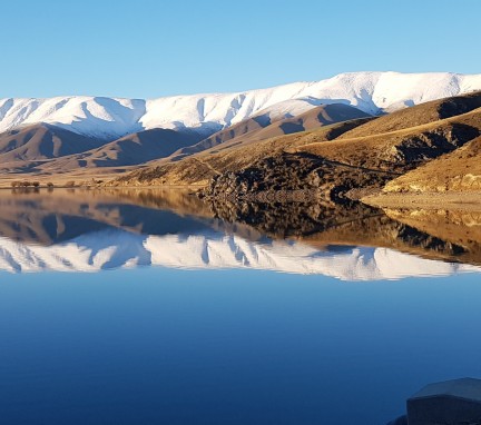
Falls Dam - An irrigation impoundment now over 80 years old. Falls Dam is high up and highly coloured, bright blue, except when it is frozen over. Oteake Conservation Park and the Hawkdun Range make a wonderful backdrop to the Dam.
The dam has a "Glory Hole" which works a lot like the drain in the side of your sink. When water gets too high it spills into the drain to prevent overflow. The Glory Hole itself is an impressive structure.

Photo: Otago Daily Times
The dam is fifteen minutes off the main road to St Bathans. A gravel road leads up to the dam. From there you have views out across the surrounding countryside to the mountain ranges.
Upper Manorburn Dam - If you're keen on fishing, Upper Manorburn Dam should be to your liking. Nestled in the hills of Ida Valley, the dam has 14km of shoreline and more than enough room to accommodate an angler or two! Rainbow trout is the catch of the day here, and worm fishing, trolling and fly fishing are all methods that can help you land the big one.

The Upper Manorburn Dam, completed in 1914 and administered by the Ida Valley Irrigation Company, is situated south-east of Alexandria North of Lake Onslow. The dam is 700m above sea level in the Central Otago Plateau. This 700ha dam combines two deep reservoirs connected by a gorge called The Narrows.
Access to the area can be from either Omakau or Oturehua on the tar sealed Ida Valley Road.
Loganburn Dam - also known as 'The Great Moss Swamp' lies in the Maniototo, close to the former gold mining route of the Old Dunstan Road. It is classified as a regionally significant wetland.
The dam lies on the upper surface of the Rock and Pillar Range, originally an actual swamp, a dam to store water for irrigation and hydroelectricity has turned the 'swamp' into a lake. The swamp is drained by the Logan Burn, which feeds into the Taieri River at Paerau.
The Loganburn Dam was finished in 1983, providing irrigation for 60 farmers and power generation when water is released for irrigation.